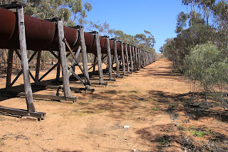
Hi all, well here we are again with a bit more of our WA trip. We decided to follow the Golden Pipeline from Mundaring to Kalgoorlie as this was an amazing achievement when The Goldfields Water Supply Scheme commenced construction in 1898. The pipeline is 500 km's long and the goldfields were 390 meter's above the proposed dam and would cost 2.5 million pounds it was the equivalent of the colony's entire annual budget.
 |
| No 1 Steam Pump Station at Mundaring |
The then Premier Sir John Forrest invited CJ O'Connor to become WA's Engineer-in-Chief to complete a program of public works that included a new harbour for Fremantle and a network of railroads and the Goldfields Water Supply Scheme. O'Connor was not daunted by the size of the scheme, he worked out that dividing the system into 8 sections with pump stations and receiving tanks at each pump would provide for the lift need to get the water to Coolgardie.
 |
| Interior of No 1 pump station |
 |
| Fire Boxes of the boilers at No 1 Pump station |
Because of the remote country and the supply of spare parts O'Connor standardise the machinery as much as possible. When all the equipment arrived from England only one half-inch hydraulic valve was reported missing, quite an amazing feat really.
 |
| Poole Street Bridge |
We left Caversham and headed to Northam to see the Pool Street Bridge, we had lunch in the car park as no room in the inn, ha ha, really no room for our rig in he caravan parking as full of car for the tourist centre committee.
The Pool Street Bridge was one of the ways to get the pipeline across rivers and salt lakes. It's a shame that this bridge is in such poor condition and that the National Trust don't repair it so that it could be used for foot traffic to cross the Avon River.
From Northam we continued east through to Meckering, stopped to look at the memorial rose garden, nice and The Big Camera "photographic museum" not open. The earth quake centre we missed as it was in a gabzoo I think.
 |
| No 3 Steam Pump Station at Cunderdin |
We arrived later in the day at Cunderdin and went to the No 3 Steam Pump Station which is now a National Trust Museum, we learnt a lot about the pipeline here. Ian looked at all the old machinery while I looked at the PMG exchange, (I think I may have learnt to be a telephonist on one of these exchange) When the museum closed we moved onto the Caravan Park.
 |
| Wooden Pipe used between 1933 to 1937 |
The pipe that he decided to use was a new radical pipe designed by Mephan Ferguson as the traditional method used rivets which leaked and obstructed the water flow. The new "locking bar" pipes were lighter and cost less. Some of the original pipes are still being used today.
 |
| Section of the pipe showing side seem and the locking ring |
Following morning we moved on on our east ward journey but stopped to view the Ettamogah Pub in Cunderdin, bit out of place I think.
 |
| Ettamogah Pub in Cunderdin WA |
We call into Tammin to see the Hydrology Model, but did not find it, no signs anywhere other than "Keep Out". So on we went to Kellerberrin.
 |
| Grain storage at Tammin |
In Kellerberrin we decided to drive up the Kellerberrin Hill to see the view over the grain fields, we had hoped to get to the top but the track turned very narrow and one vehicle wide so turned round at the first opportunity not being sure if we could at the top as we had the van on, but the views we did get were great.
 |
| Looking North on the road up Kellerberrin Hill |
 |
| Kellerberrin Hill |
 |
| Ian with the wild flowers on Kellerberrin Hill |
An interesting feature here was the water catchment walls and channels moving the water to the railway dam. The hill is one huge granite outcrop.
 |
| The water collection walls on Kellerberrin Hill |
From here we continued on through Old Doodlakine with a closed tavern. Just near Doodlakine we came across the Baandee Lakes, these lakes are salt water lakes when it has rained and dry salt lakes otherwise. These lakes in the 1903s were mined for Gypsum not quite what you expect.
We pulled into a rest area and went walking across the road to get a better look at the salt lake which had water in it by the way, to find behind the new pipeline the remains of the old one.
 |
| The pipeline where it crosses the Baandee Salt Water Lakes |
 |
| Behind the new pipe are the remains of the old pipeline |
Continuing on east we came to No 4 Pump Station, Merredin. This is very interesting Pump Station as there are 3 different generations of pump here. You have the original old steam pump, the first generation of electric pump station built in the 1950s' and then the current electric pump constructed in 2001. 3 pump stations over 100 years.
 |
| Steam pump station no 4 completed in 1902 |
 |
| The second generation electric pump station built in 2001 |
Further along the road we passed through Burracoppin and stopped at the No 1 Rabbit Proof fence, then passed No 5 pump station to spend the night at the Southern Cross Caravan Park.
 |
it was 1,833 km's long running north south |
Southern Cross has a great look out on Wimmera Hill, next morning on the last leg of our drive along the pipeline we stopped at the No 6 Steam Pump Station, this pump station has a steel chimney and still standing the weighbridge. Here are the remains of a children's playground. An interesting piece of trivia is that in WW11 the pump stations and weir were guarded by various groups including Special Police and the army. The 374 km mark is on the gravel road the runs along the old railway embankment and one way so we gave it a miss as the van is on the back. Also in this area are some of the wooden pipes that were laid in the 1930s.
 |
| No 6 Steam Pump Station at Ghooli |
 |
| The weighbridge at No 6 pump station |
From the 374 km mark we went onto Karalee Rocks, this is a beautiful place and good camping with fire places in each spot, also a dump point. We had lunch and a good walk around here, the water was for the steam trains that run between Perth and Kalgoorlie.
 |
| Granite rock of Karalee Rocks |
 |
| Water collection wall at Karalee Rocks |
 |
| Stone inlet channel leading from the rock o the steel flume |
 |
| Water direction sluice gates on the steel aqueduct or flume |
 |
| The steel aqueduct or flume that carries water from the rock to the dam |
 |
| Water enters dam here from aqueduct or flume |
 |
| The dam |
 |
| Some of the local wildlife |
We continued past No 7 Pump Station at Gilgai and headed onto Woolgangie railway station, here the track follows the railway embankment and the pipeline to No 8 Pump Station, Dedari this is the most intact of all the remaining pump stations, it was closed in 1970.
 |
| The remains of the railway station at Woolgangie on the pipeline |
 |
| The pipeline |
 |
| No 8 steam pump station |
 |
| More of the pipeline at no 8 pump |
 |
| More of the pipeline |
 |
| Pipeline at Coolgardie |
In Coolgardie the pipeline went to Toorak Tank which when the pipeline started was to be the end of the line, but as gold was found in Kalgoorlie it continued on to Mt Charlotte and supplied this town with much need water.
 |
| The end of the pipeline at Mt Charlotte Kalgoorlie |
Well we finished the drive in Kalgoorlie and stayed for a few days. So for now I shall say see you all soon. Cheers Marilyn


0 Comments:
Post a Comment
Subscribe to Post Comments [Atom]
<< Home