Well here we are again, on our journey west. We decided in Ceduna that we would do the Nullarbor Links course going west/east, this shot of Ian was at Penong (town of windmills, there are a lot of them) This was a nice straight hole to play which was fun.
 |
| Ian teeing off on the course in Penong |
From Penong we had an over night free camp just east of Nullarbor, which was nice 2 other rigs came in after us. This sign is one of many to keep your mind on the road. The driving is easy so Ian said just point the truck in the right direction & let it do the rest.
 |
| First of many funny signs, this appeared every 92km |
 |
| A bit of straight flat road |
Crossing the Nullarbor National Park was interesting as I kept watching for a change but none happened till Border Village. We had a few stops along the way to look at the fabulous cliffs & boy are they something. To early for the whales so the Head of the Bight viewing was closed.
 |
| View to the right, flat treeless Nullarbor |
 |
| Shells & grass on top of the Bunda Cliffs |
It is surprising what you find sometimes when you are looking around, like shells in the sand & rock on top of the cliffs (how long have these been here)
 |
| On top of cliffs, looking East |
 |
Looking West
We finely reached the border of SA & WA after stopping for a break to eat our last apple, (they won't get any more fruit from me, ever again) A bit more impressive than the Vic / SA border. |
 |
| Another border to our list |
 |
Sand hills @ Eucla
|
From the border we continued to Eucla for the night, just got in in time to get a nice bit spot for our van, by 5pm there would have been 30 + rig in this little park. we unhitched the truck & went for a drive to see the Telegraph station, I do admire the wives & family that went with the operators of these stations with what they put up with.
 |
| Ruins of Telegraph Station @ Eucla |
 |
| Telegraph station @ Eucla |
The gums behind the ruins are huge old trees, not at all like the other bush around, must have been planted by the staff of the station. This lookout is on top of the cliffs looking south, there is a memorial here to the explorer "Eyre" & for all travelers as well, great views from this spot.
 |
| Looking to the Telegraph station & South from lookout @ Eucla |
 |
| Long way from home but still long way to go |
From Eucla we went down to the Hampton Plains from the tableland & continued over a area with low scrub & lots of sand to ascend again to the tablelands at Madura Bluff, we overnighted @ Cocklebiddy roadhouse, we had hope to go out to the Eyre Bird Observatory @ the Eyre Telegraph station but you have to ring & book ahead, you can't take the van out either so it is a 2 night stop to see the birds (maybe on the way back) At around Graiguna is this great sign, (don't know if we can take anymore straight roads)
 |
| start of the long straight drive, (more) |
 |
| Centre of sign has changed to Emu from Wombat (don't want to hit either) |
I must be getting board or something I keep taking photos of sings.
 |
| The Eyre Highway, straight as a die with little hills |
 |
| Ian is concentrating on the straight road, |
 |
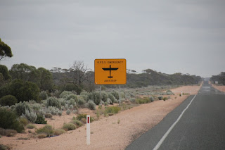
| Another sign to keep us alert, planes this time |
This one a week after we crossed was used to land the Flying Doctor's plane on, glad we were not there (although it would have add somewhat to the drive) We stopped at Balladonia for the night where is rained then Norseman before heading to Kalgoorlie as we could not get a site in any parks in Esperance as it was school holidays & Easter. Whilst in Kalgoorlie we did tourist thing like the Miners Museum, Kalgoorlie Museum, swimming & played 2 more holes of golf @ the new Kalgoorlie Golf course.
 |
| In the hand dug goldmine where Kalgoorlie started |
 |
| A quarts vain containing GOLD |
 |
| The tunnel that the men worked in |
 |
| Typical houses of the time |
 |
| Kalgoorlie from the water tank look out |
 |
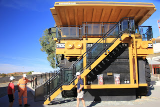
| This truck is bigger than ours |
 |
| Broad Arrow Pub, |
On booking the Super Pit tour we found out about another 4 X 4 tour but did not want to pay the high price so did it by ourselves, this was part of the Golden Quest Discovery Trail. We left Kalgoorlie about 9.30am and headed to Broken Arrow, Ora Banda (pub not open on Saturday till 11am), Siberia, Davyhurst, Ularring Soak, Mulwarrie, Snake Hill lookout (for a look at Lake Ballard & lunch), Lake Ballard & the Gormley sculptures (3.30pm to late to see all 50), Menzies for a quick beer before the drive home, we passed the Gidji Roaster & the 2up School before getting back at 6.30pm to Kalgoorlie, just a short drive of 350km to see some sculptures. We had a very interesting day
 |
| The 100 year old Ora Banda Pub |
 |
| Ularring Soak area form by Ernest Giles the explorer in 1875 |
 |
| This is the soak (well) |
 |
| Salmon Gums on the road between Ora Banda & Siberia (ghost town, nothing at all left) |
 |
| Whites Well, note the new poly tank & the old rusted tin ones |
 |
| Lake Ballard from snake hill lookout |
 |
| The Gormley sculptures of the "Inside Australia" exhibition on Lake Ballard |
 |
| There are some 50 of these sculptures on the lake |
 |
| Menzies town hall |
 |
| setting sun on the Goldfields Highway |
On another day we did another 4X4 tour along the Golden Pipeline as far as Woolgangie
 |
| The Oka line up @ Coolgardie |
 |
| Jack Carins camp (old prospector) |
 |
| No 8 pumping station on the Golden Pipeline |
 |
| The Golden Pipeline of today |
 |
| Bronze-tinted Gimlet (beautiful tree) |
 |
| Ernest Giles grave in Coolgardie |
Whilst in Coolgardie on our pipeline tour we stopped at the cemetery to view Ernest Giles grave a very interesting explorer in the late 1870's
 |
| Storm coming over the Coolgardie cemetery |
Well hope you like the photos etc: I will have to do The Super Pit Tour next as just too many photos to try & show you. We found the 4 x 4 tours to be expensive for what you get so we did our own by buying a book, getting a pamplet & off we went. Love to all Marilyn & Ian


1 Comments:
love those sculptures around the lake... very cool
Post a Comment
Subscribe to Post Comments [Atom]
<< Home